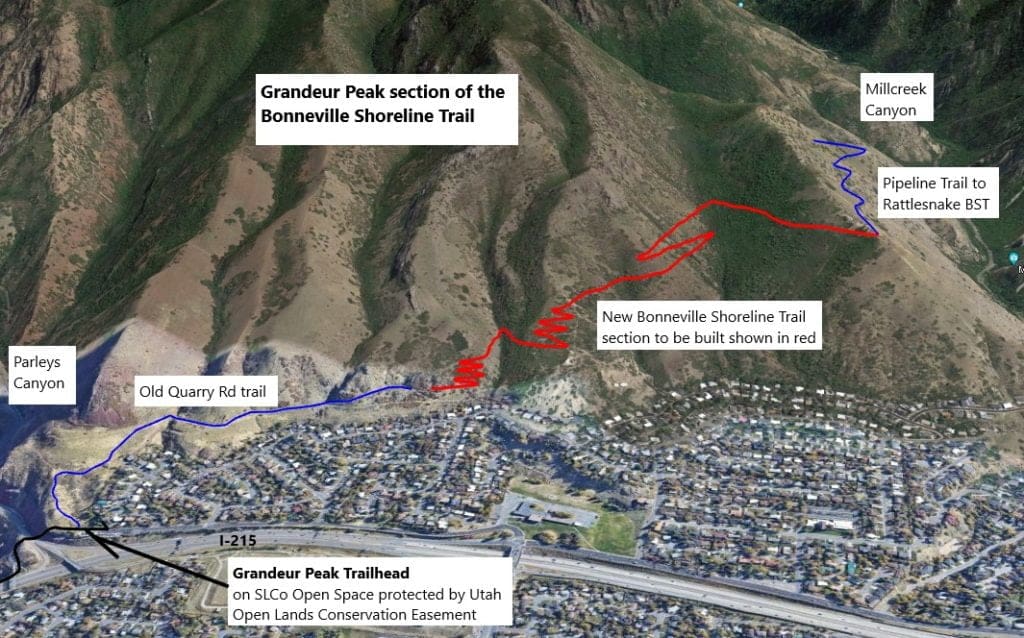
About the Grandeur Peak to Pipeline Connector Trail
In this trail project, Trails Utah was able to construct two miles of new Bonneville Shoreline Trail (BST) on the west flank of Grandeur Peak. This critical new trail section now connects the west end of the Pipeline Trail in Millcreek Canyon to the lower Quarry Trail accessed via the Grandeur Peak Trailhead.
With the completion of this BST section, Grandeur Peak Trailhead to Pipeline Trail now creates a continuous BST segment from Millcreek Canyon to Parleys Canyon!
Trails Utah's role in the Grandeur Peak BST Connector
This non-motorized section of BST between Millcreek and Parleys Canyons has been in high demand and planned for over 20 years, but the project was not been feasible due to private property holdings across the west side of Grandeur Peak. The final two private parcels were purchased by Salt Lake County with funding from the Utah Office of Outdoor Recreation and this segment, which includes USFS property, is included in the 2005 Salt Lake County BST Master Plan. NEPA environmental assessments found no significant impact.
In 2021 a new Rattlesnake segment of BST was built from the Rattlesnake Trailhead in Millcreek Canyon to the Pipeline Trail by Trails Utah in cooperation with the USFS.
Also in 2021, a new four-mile segment of BST was built by Trails Utah going north from Parleys Canyon to Carrigan Canyon. Both of these new trail segments were immediately embraced and heavily used by the community. This section of BST will join these two new trails creating almost 10 miles of continuous BST, including the paved trail and existing pedestrian bridges over I-80 at Parleys Canyon.
With support from the Utah Division of Outdoor Recreation, US Forest Service, Salt Lake County Open Space, and the City of Millcreek, Trails Utah has now completed this section of the Bonneville Shoreline Trail that now connects the end of the Pipeline Trail (Millcreek Canyon) to the Grandeur Peak Trailhead!
Granduer Peak Trailhead to Pipeline Trail is a multi-use trail open to hikers and mountain bikers.
This trail is on Salt Lake County Open Space and protected by Utah Open Lands Conservation Easement.
Become a member today and help complete the 280-mile vision for the Bonneville Shoreline Trail ⛰️
Type in Grandeur Peak (face) Trailhead (located at 2900 Wasatch Blvd) on your favorite GPS tool and you’ll be taken directly to the trail head.
Don’t have GPS? To get there, take exit 3 from I-215 S. You’ll then turn left at the light, another quick left onto UT-171 E., then continue straight onto 3300 S./Wasatch Blvd. Take this for about 0.6 miles and you’ll see the trailhead.
This trail has room for about 20 cars, plus additional space just outside the gate (which gets locked at 10pm).
Grandeur Peak BST details
Region: Salt Lake Valley
Distance: 2.7 miles
Elevation Gain: 1,046 feet
Dogs Allowed: Yes
Restrooms: No
Horses: No
Wheelchair accessible: No
Difficulty: 3.5/5
While grants cover some costs, donations and membership dollars are crucial for ongoing planning and environmental reviews. Consider supporting Trails Utah through donations or becoming a sustaining member.